[Data & Code] A drone imagery dataset for semantic segmentation of urban garden ground covers in biodiversity studies
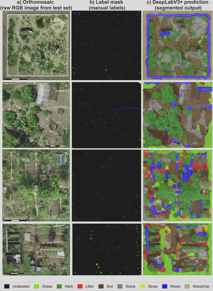 Visual comparison of ground-cover semantic segmentation on test-set orthomosaics: RGB tile, eight-class label mask, and the DeepLabV3+ prediction.
This dataset accompanies the Data Descriptor published in Scientific Data by Afrasiabian et al. (2026), providing a high-resolution benchmark for mapping the fine-scale ground-cover heterogeneity of urban community gardens.
Urban gardens support city biodiversity through diverse ground covers that provide habitat, pollination, pest control, and soil functions — but their spatial heterogeneity has been poorly mapped due to a lack of high-resolution imagery. This dataset addresses that gap.
What’s in the dataset
- 24 RGB orthomosaics (GeoTIFF) and their 24 pixel-level label masks, collected in 2021–2022 at five community gardens in Munich, Germany
- Organised into Train / Val / Test splits (14 / 5 / 5 orthomosaics and masks)
- Spatial resolution 3.2–7.9 mm per pixel (18.9–146.4 megapixels; EPSG:25832)
- Eight ground-cover classes: grass, herb, litter, soil, stone, straw, wood, and woodchip
- A patch-based version (cropped image/mask patches) ready for deep-learning pipelines
- A metadata CSV documenting per-image dimensions, resolution, CRS, and Agisoft processing/flight properties
Benchmarks
The descriptor benchmarks both deep-learning (UNet, DeepLabV3+) and traditional machine-learning (Random Forest, XGBoost, Maximum Likelihood) classifiers. DeepLabV3+ achieved the best performance, with an overall accuracy of ≈93.2% and an Intersection-over-Union of 69.4.
The dataset is intended to support research on urban biodiversity, habitat modelling, garden management, and remote sensing, and can be combined with other fine-scale datasets to advance sustainable urban green planning.
📦 Dataset (Zenodo): https://doi.org/10.5281/zenodo.18757882
💻 Code (GitHub): https://github.com/paglab/ugc-mapping
📄 Citation:
Afrasiabian, Y., Lu, C., Belwalkar, A., Elsharawy, H., Song, X., Yuan, Y., Wu, F., Su, X., Van Cleemput, E., Egerer, M., & Yu, K. (2026). A drone imagery dataset for semantic segmentation of urban garden ground covers in biodiversity studies. Scientific Data, 13, 590. https://doi.org/10.1038/s41597-026-07152-z
Yasamin Afrasiabian
PhD student
My research interests include remote sensing, particularly hyperspectral UAV and satellite imaging, and machine-learning methods for ecosystem-biodiversity characterisation, precision agriculture, and hydrological analysis.
Chenghao Lu
Research assistant & Joint Phd student
My research interests are Agricultural Digital Twin and Smart Breeding. My project focuses on the construction of a Digital Twin system for maize, aiming to fuse Genetic x Environmental x Management data to construct a high-precision and dynamically updated maize growth virtual twin. By introducing a DNA language model with a multimodal fusion approach, I hope to achieve accurate simulation of maize phenotypes and breeding to support sustainable agricultural development.
Dr. Anirudh Belwalkar
Postdoctoral Researcher
My research interests include hyperspectral remote sensing of vegetation and precision agriculture.
Hany El Sharawy
PhD Student
My research focuses on UAV-based phenotyping, hyperspectral remote sensing, and high-throughput phenotyping of maize under drought conditions.
Xiaoxin Song
PhD Student
My research interests include multi-scale plant and crop phenotyping, crop growth and senescence monitoring, dynamic modelling, and remote sensing.
Ying Yuan
PhD student
My research focuses on remote sensing phenotyping of winter wheat, including ground-based and UAV-based hyperspectral remote sensing, solar-induced chlorophyll fluorescence remote sensing…
Prof. Dr. Kang Yu
Professor of Precision Agriculture
My research interests include precision crop farming, hyperspectral remote sensing, and AI in agriculture.