Latest News


Our recent publication Gackstetter, Yu, Körner 2026 ISPRS addresses the critical challenge of improving satellite image classification when target labels are scarce, a common issue in remote sensing. We focus on developing effective methods for unsupervised domain adaptation (UDA), specifically through our proposed model, RAINCOAT-SRS, which builds upon existing UDA techniques tailored for satellite image time series (SITS). This work connects with our previous work while enhancing classification accuracy by employing self-attention mechanisms and frequency-augmented features. By comparing RAINCOAT-SRS with other leading algorithms like TimeMatch, we discovered that our model outperforms standard methods. This work emphasizes the importance of domain stability and structural patterns rather than merely linear shifts between domains, contributing significant insights into UDA effectiveness. Our findings provide a novel framework for tackling the complexities of SITS classification, promoting more effective cross-regional and multi-temporal analyses.
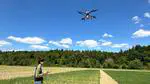
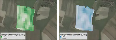
Our recently accepted two papers by Wang J et al. (2025) and Wang F et al. (2025) investigated drone remote sensing data-driven models for crop nitrogen estimation.
Both works utilize drone remote sensing technology to explore nitrogen dynamics in wheat, aiming to enhance nitrogen use efficiency (NUE) in agriculture.
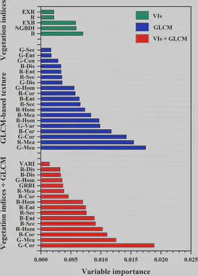
The Yin et al. 2025 paper aims to understand which types of features extracted from drone RGB images predict potato aboveground biomass (AGB) more accurately across different growth stages.
The innovation lies in the approach of integrating color indices with the gray-level co-occurrence matrix (GLCM) and Gabor wavelet textures.
Our results demonstrated that combining the color (spectral) features and texture features could significantly enhance predictive accuracy,
whereas different features varied a lot in their contributions to model performance.