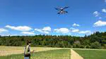
Drone Remote Sensing

Our research team has introduced a novel approach (Song et al. 2025) to quantify wheat senescence dynamics by integrating UAV-based multispectral imaging with generalized additive models (GAMs).
Unlike traditional methods that capture only single time points, this study tracked the entire senescence process throughout the growing season and validated it, in collaboration with Prof. Minceva’s Lab at TUM, using laboratory measurements of leaf anthocyanins. The results revealed clear nitrogen-related differences among wheat varieties, demonstrating that the area under the curve (AUC) of UAV-derived vegetation indices strongly correlates with grain yield.

Our recently accepted two papers by Wang J et al. (2025) and Wang F et al. (2025) investigated drone remote sensing data-driven models for crop nitrogen estimation.
Both works utilize drone remote sensing technology to explore nitrogen dynamics in wheat, aiming to enhance nitrogen use efficiency (NUE) in agriculture.
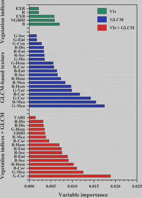
The Yin et al. 2025 paper aims to understand which types of features extracted from drone RGB images predict potato aboveground biomass (AGB) more accurately across different growth stages.
The innovation lies in the approach of integrating color indices with the gray-level co-occurrence matrix (GLCM) and Gabor wavelet textures.
Our results demonstrated that combining the color (spectral) features and texture features could significantly enhance predictive accuracy,
whereas different features varied a lot in their contributions to model performance.